
If you’re in the geothermal energy industry, you know how vital it is to have a clear understanding of your thermal assets. Our technology and expertise enable you to harness the power of aerial thermal imaging to gain critical insights into your geothermal operations. Since 2010, we’ve been providing that clear understanding of surface thermal expressions. There was even an opportunity to co-author a paper with the USGS, titled ‘Monitoring Ground-Surface Heating During Expansion of the Casa Diablo Production Well Field at Mammoth Lakes, California.’ You can find a link to that paper here: https://pubs.usgs.gov/publication/70159383 and the direct PDF here: https://publications.mygeoenergynow.org/grc/1032246.pdf
Geothermal power production is on the rise, and with it comes the need for accurate and efficient monitoring of thermal assets. Aerial thermal imaging is revolutionizing the way we assess and manage geothermal resources. Here’s why it matters:
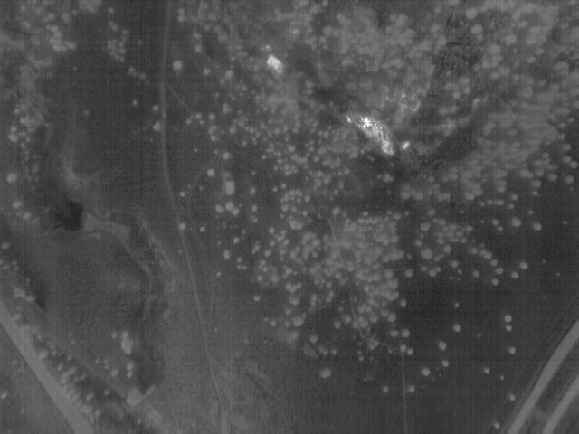
Identifying Thermal Anomalies: Our high-resolution thermal imaging captures even the subtlest temperature variations, allowing you to pinpoint thermal anomalies that may indicate reservoir changes, pressure variations, or potential issues.
Monitoring Ground Temperatures: With our technology, you can closely monitor ground temperatures across your geothermal site, enabling you to optimize well field placement, assess reservoir health, and mitigate environmental impacts.
Detecting Human Activity: Aerial thermal imaging not only helps identify natural thermal features but also distinguishes them from human activities. This capability is crucial for assessing the impact of geothermal development on surrounding areas.
We offer state-of-the-art aerial thermal imaging services tailored to your geothermal needs:
High-Resolution Imaging: Our technology provides pixel-perfect detail, ensuring that you don’t miss any critical thermal information.
Customized Data Analysis: We don’t just capture data; we analyze it comprehensively, providing you with actionable insights and reports to inform your decisions.
Regular Monitoring: Whether you need periodic assessments or continuous monitoring, we’ve got you covered, ensuring your geothermal operations are always in focus.
Ready to take your geothermal operations to the next level? Contact us today to discuss your specific needs and discover how aerial thermal imaging can empower your business.